Department of Geosciences
Career Mentoring
Geoscientists are some of the most highly sought after science professionals in the world. The global demand for geoscientists in areas such as environmental science, geographic information systems, and mineral resource extraction far exceeds the currently available workforce. Furthermore, the demand for geoscientists is expected to increase as global demand for natural resources increases and the environmental and climate impact of human activity expands into new geographic and biological ecosystems. Many of our graduates are employed with environmental consulting firms, government agencies, and energy and mining companies. Because meaningful and rapid availability of data is vital to all geoscientists, many graduates find employment as specialists in the rapidly expanding field of geographic information systems and remote sensing.
Some of our graduates go on to earn masters and doctoral degrees at some of the nation’s most prestigious research universities. Importantly, the extensive interdisciplinary course of studies provided by the degrees in our department also prepares graduates for careers in many geoscience-related professions, such park service, science journalism, and science education.
Finding a career after graduation can be confusing and difficult at times. Below you’ll find a list of career areas and the faculty in the department that can provide mentoring help for each. We may be teachers now, but many of us have industry and government experience as well. Keep in mind that some of these careers will require a graduate degree to enter and be successful, an undergraduate degree may not be enough.
Feel free to reach out to us with any questions you might have! Is there a career you’re interested in, but it’s not listed below? Let one of us know and we can help point you in the right direction!
More Information on Geoscience Careers:
- Geoscience Graduates First Jobs
- Median Salaries for Geoscience Workforce Occupations
- Explanation of Predicted Geoscience Workforce Shortage
- U.S Bureau of Labor Statistics – Occupational Outlook for Geoscientists
- GISjobs.com
- The GIS Jobs Clearinghouse
- The Geosciences in Tennessee
- Physical Geographers at MTSU
Follow Us!
Faculty Spotlight
Alan Brown:
"I did not start out in college thinking I would be a Geology major. In fact, I had little idea what a Geologist even was. It was my first class in Geology that ignited my love of Geology and Paleontology. I had a strong interest in Paleontology while in school but decided to focus instead on environmental geology because the job market was much better. After getting my Master’s degree I worked as an environmental consultant for 7 years.
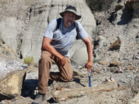
Then, in 2005, I was hired as an instructor at Middle Tennessee State University. Once I started at MTSU my interest in Paleontology was rekindled. In the summer of 2009, I was invited to go on a dinosaur dig in Montana and I have returned to Montana to dig up dinosaurs every summer since. I volunteered at two museums in the area but they both closed. I then got together with a small group, and we decided to start a new museum. This museum is Earth Experience the Middle Tennessee Museum of Natural History in Murfreesboro, Tennessee, which opened in 2014. It is my passion and takes almost all my free time."
Contact Us
Mail address:
MTSU - Dept. of Geosciences
MTSU PO Box 9
Davis Science Building 241
Murfreesboro, TN 37132
Dr. Todd Moore, Department Chair
615-898-2379
Karen Wolfe, Executive Aide
615-898-2726


