Archaeology at Bledsoe's Station, 1996-2001
Four summer field schools focused specifically on the archaeology of Bledsoe's Station -- 1996, 1997, 1998, and 2001. From the very start, the project proved to be more complex and productive than any of us had imagined.
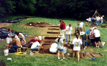
In 1996, the equivalent of forty 5x5 foot units were hand excavated (about 1000 cubic feet of dirt!). The locations of five structures were discovered as evidenced by subfloor cellar features. Because the structures were simple log cabins (without stone or concrete foundations), the main evidence for their location are small "root cellars" or pit cellars excavated into the subsoil beneath the cabins. Given that we had anticipated finding only a total of three or four of these cabins at the site, the rapid discovery of five cellars added to the three previously investigated in 1993 and 1994 was a startling revelation of things to come.
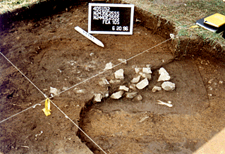
Feature 105 -- one of the pit cellars discovered in 1996 -- before excavation. The outline of this cellar is best seen in the lower right corner of the photo where the orange-brown subsoil clay stands out against the darker brown sediments filling the cellar. Also note that the material filling the cellar contains limestone "chunks" tossed into the cellar at the time of demolition of the cabin. The majority of the limestone was probably used as "chinking" between the logs of the cabin walls and in the chimney.
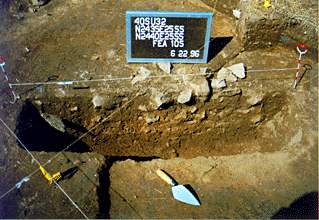
Feature 105 "profile". Excavation of each large feature is conducted in "halves" -- allowing the archaeologists to examine the layering of the fill in the cellar. In this photo, half of the feature has been excavated to its base -- the "profile" or side-view of the remaining half shows two distinct episodes of filling. The bottom is comprised of darker brown fine-grained sediments that washed in (or fell through the cracks in floorboards) while the cellar was in use. The upper fill results from waste disposal after the cellar was no longer in use -- and probably from the time the cabin above it was demolished. The second half of the cellar is excavated using the information gained from the profile -- artifacts from each "fill episode" are kept separate. By keeping these artifacts separate, the dates of the occupation and demolition of the cabin can be established.
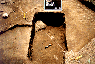
Feature 105 -- after excavation was completed. In this photo, the fill of the cellar and all artifacts has been removed. The white object in the bottom of the cellar is a natural limestone boulder -- left in place by the pioneers who originally dug the cellar. We "re-encountered" these naturally occurring boulders in several of the cellars -- like the pioneers, we left them in place! Few other surviving archaeological features attest to the location or orientation of these log structures -- relatively low quantities of nails and the absence of brick and window glass indicate buildings serving as relatively short-term housing. Several units were placed across structures with the hope that artifact patterns will yield clues to size and orientation.
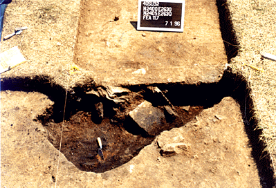
Feature 117 -- another cellar discovered in 1996 under excavation. From the amount of charcoal, ash, and burned clay chinking in the upper layers, it appears that this cabin burned (intentionally or unintentionally) -- tumbling remnants of the building into the cellar. Some of the stones visible in the partially excavated cellar are apparently hearthstones from the fireplace, while others are probably chinking from the cabin chimney and walls.
Each of the five cellars yielded an impressive collection of ceramics, bone, straight pins, tobacco pipes, and other objects of daily life. Of significance is the discovery of a cufflink set bearing a running fox and "TALLIO" similar to artifacts recovered from three early federal military sites in Tennessee (Fort Southwest Point, 1797-1813; Tellico Blockhouse, 1794-1807; Fort Blount, 1794-1807).
Our discoveries in 1996 indicated that Bledsoe's Station was a much larger and more complex "fort" than indicated by the documentary record. The documents recorded only three-four cabins surrounded by a stockade -- we had already identified eight cabins (but no stockade!). When we returned for another summer in 1997, a broader strategy of investigation was planned to help direct our efforts.
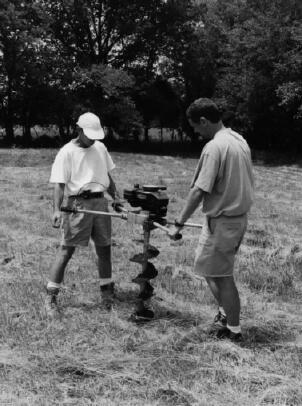 In 1997, an extensive gasoline-powered auger testing program was conducted at 20-foot
intervals across the entire site area (over 200 tests). Soil from each auger test
was screened and artifacts were rapidly inventoried in the field into broad categories
(ceramics, glass, nails, daub, chinking, etc.) The overall distribution of artifacts
provided clues to the size and shape of the fort. These distributions were further
analyzed to generate density maps for specific artifact types -- particularly architectural
materials such as nails and chinking -- in order to guide the placement of excavation
units. The distribution of nails from this testing program showed four clear peaks
representing the corners of the fort enclosure -- where presumably the most strongly
built structures were located (interpreted in three cases as "blockhouse" type structures).
In addition to the auger program, the equivalent of 30 5x5 foot units were hand-excavated (ca. 750 cubic feet). An additional three pit features (cellars) were discovered during this season. While we now had a good idea of the core of Bledsoe's Station from the artifact distributions discovered in the auger program, we had now discovered eleven buildings on the site. We had not yet discovered any signs of the palisade wall surrounding these structures.
Having hand-excavated almost 2000 cubic feet of the site, I felt we had an adequate control of the site stratigraphy. Bledsoe's Station had been plowed as a field for decades after it was taken apart in the late 1790s and early 1800s -- we were not learning much by hand excavating the upper levels of the site. We did recover some artifacts, but they had been broken, moved, and displaced by the plowing and erosion.
When we returned in 1998, I elected to use some mechanical assistance in addition to our hand-excavations -- primarily to help find the still elusive stockade surrounding the site. At the periphery of the artifact distribution shown in our 1997 auger-testing program, a series of slot trenches and strip blocks were investigated using a backhoe. The backhoe was used to carefully and cautiously remove the "plowzone" -- the part of the surface deposits that had been disturbed and mixed by agricultural use of the past several decades. Below this disturbed zone, the surviving features related to the fort were readily identified. The use of heavy equipment should never be undertaken lightly on an archaeological site -- but given the knowledge developed in our 1996 and 1997 seasons, we were able ot quickly expose large areas in search of the palisade without losing much critical archaeological information.
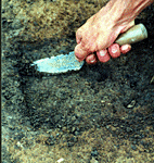 The backhoe proved to be a useful tool in this case -- fortuitously, the stockade
was revealed in the first mechanically excavated strip block. The photograph at right
shows the narrow trench (dark-colored soil bounded on the top and bottom by the lighter
colored clay subsoil) that once held the posts of the wall surrounding the fort. The
feature was followed for approximately 120 feet on the east and south sides of the
fort enclosure. Excavation of the feature revealed post impressions at the base of
a shallow remnant of the stockade ditch. Plowing and subsequent erosion of the feature
had removed all but the bottom few inches of the ditch in this area - underlining
the critical need for preservation of these early frontier sites.
At the end of 1998, we believed that most of the stockade trench had been obliterated on the northern and western sides of the original enclosure. Further work in 2001 proved that we were wrong -- we were just looking in the wrong place. Unlike many reconstructions of the frontier station sites, the stockade wall was not a neatly designed structure - post impressions reveal an eclectic and somewhat haphazard construction using a variety of log sizes. In addition the stockade wall was not squared off, and is best described as a series of noncontinuous wall segments connecting apparently pre-existing structures.
A by-product of the backhoe stripping operations was the discovery of seven additional pit cellars. While we had found our stockade wall on two sides -- we had also expanded the complexity of this small frontier station further.
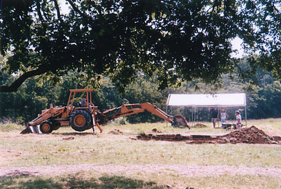
We were not able to return to Bledsoe's Station for another field season until June 2001. Having developed what we felt was a reasonable interpretation of the fort layout based on our work in 1996, 1997, and 1998 -- our investigations during 2001 were extensive. Machine-assisted stripping was used in several selected areas to identify all of the remaining major features within the stockade walls. The results of the testing clearly demonstrate the value of the scientific method in guiding investigations. The remaining stockade walls were discovered because of systematic examination of areas thought NOT likely to contain features. In this case, the scientific method required us to examine those areas -- and sure enough, they revealed critical features for the final interpretation of the fort.
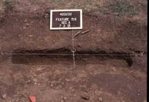
On the northern periphery of the site, an 80-foot-long segment of stockade was discovered (Feature 156). The trench was continuous from the northwest to northeast corner -- except for one spot where the builders encountered a large limestone boulder. The trench was well preserved. Its unexpected location forced a reinterpretation of the two cabins located on the northwestern periphery of the site. Borne out by artifact studies in the lab, it is now believed that these cabins were slave quarters for the Belote family used after 1806.
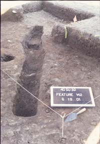
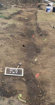
The elusive western wall was also finally revealed by systematic examination. Prior testing had not revealed vestigates of this wall because it consisted of only a few discontinuous short trench segments between cabins. The cabin walls themselves constituted the majority of the defensive wall on the west. The spacing of these trench segments permitted an interpretation of the average size of the structures at the site -- twenty by sixteen foot structures fairly neatly fit the pattern of gaps and cellars. On three corners, the gaps suggest square structures rather than rectangular ones -- hence the final interpretation of those three as twenty-foot square blockhouse-type structure.
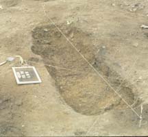
The placement of a large oval pit provides some additional support for this interpretation. Feature 139 is unlike the square-rectangular pit cellar features on the site. Based on the current interpretation of the site plan, this feature would have been located inside the wall under an overhanging second story of a blockhouse. The only other oval shaped pit located at the site is interpreted as being inside the corner of a similar blockhouse on the northeastern corner of the enclosure.
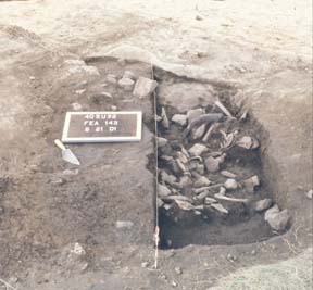
Since two rows of cabins had been postulated based on the locations of cellars discovered in earlier seasons, hand excavation focused on identifying any remaining cabins along these lines. While the hypothesis proved correct in both cases, the number and size of additional pit cellars discovered was more than anticipated. In the western row, another large cellar precisely aligned with Feature 120 was discovered. It contained large quantities of domestic refuse, including an extraordinarily large sample of animal remains (including an intact horn from an ox visible just to the right of the menu board in the photo).
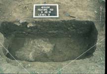
On the eastern row of cabins, another two cellars were discovered. These two cellars are placed adjacent to and just inside the presumed "gate" -- a gap in the eastern palisade directly faces the spring and is lined with heavily compacted charcoal and refuse starting inside the wall and continuing outside. William Hall's description of the fort indicates that the entrance led through a "dogtrot" in a double-cabin occupied by the Bledsoe family. The photo at right shows the smaller of these two cellars -- including another of those floating boulders.
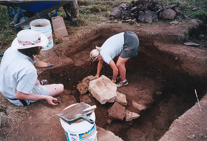
The other cellar, shown at right, was the largest of the pit cellars discovered at Bledsoe's Fort. The enormous size of this cellar, along with the most substantial set of limestone blocks recovered from the site, suggests that this was one of the primary buildings at the fort. Hence, the current interpretation of the site layout puts these two cellars beneath a double cabin with a dogtrot -- their spacing fits this interpretation fairly well. Why the eastern row of cabins lies well inside and unaligned with the stockade wall was a subject of some interpretive debate. However, the historical records suggest that the more formal stockade walls and blockhouses may have been added in 1787 -- when militia were despatched from Knoxville to help "fortify" the stations of the Mero district settlements. As a primarily "civilian fort" rather than a military fort, the somewhat eclectic design probably incorporated some existing structures while adding two blockhouses and a formal wall extending outside the otherwise rectangular plan.
Laboratory processing and analysis has been completed for the over 75,000 artifacts recovered from 1996, 1997, and 1998. Labwork is on-going but nearing completion for the additional 15,000 or so artifacts recovered in 2001.


